Posts by srwd
Stearns County Ditch #15

Stearns County Ditch #15 Location Main Start – Section 4, T-125-N, R 31W Albany Township End – Section 24, T-125N, R 32- Oak Township Branch #1 Start – NE Section 5, T-125-N, R-31-W, Albany Township End – SW Section 4, T-125-N, R-31-W, Albany Township Branch #2 Start – SE Section 31, T-126-N, R-31-W, Krain Township End – NWSE…
Read MoreStearns County Ditch #11

Stearns County Ditch #11 Location Main Start – NE Section 12, T-126-N, R-34-W, Sauk Centre Township End – Section 29, T-126-N, R-33-W, Melrose Township at confluence with the Sauk River Branch 1 Start -~Center Section 12, T-126-N, R-34-W, Sauk Centre Township End – NWSE Section 12, T-126-N, R-34-W, Sauk Centre Township Description CD 11 is approximately…
Read MoreStearns County Ditch #9

Stearns County Ditch #9 Location Main Length – 7.6 miles Start – Section 27, T-125-N, R-34-W, Getty Township End – Section 27, T-125-N, R-33-W, Grove Township Branch #1 Length – 1.57 miles open ditch and 1.89 miles of tile Start – Section 17, T-125-N, R-33-W, Grove Township End – Section 30, T-125-N, R-33-W, Grove Township…
Read MorePope County Ditch #6

Pope County Ditch #6 Location Main Length – 8 miles consisting of main channel and two branches. Start – Section 11, T-125-N, R-36-W, Grove Lake Township End – Section 4, T-126-N, R-36-W, Westport Township Description The drainage area is 13,694 acres, located in parts of Westport, Grove Lake townships in Pope County; Raymond and Ashley townships…
Read MoreWWWYD Data Sheet
Student Sheet
Read MoreSciCon Reimbursement

Form
Read MoreMinnow Respiration Lab
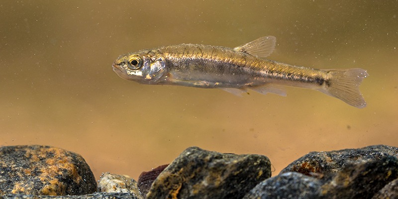
Data Analysis
Read MoreInvasive Species Transmission Activity

Activity
Read MoreInvasive Species Transmission Lab Activity

Lab Procedure
Read MoreInvasive Species Predator Activity

Invasive Species Predator Activity
Read More