Posts by srwd
Stearns County Ditch Zion-Munson

Stearns County Ditch Zion – Munson Location Start – Section 35, T-125-N, R-32-W, Zion Township End – Section 19, T-123-N, R-31-W, Munson Township Description Stearns Zion-Munson Ditch flows generally from southwest to northeast, following the topography of the landscape, constructed in the lowest part of its sub-watershed. The ditch is approximately 3 miles in length…
Read More10/14/2020
Sauk River Comprehensive Watershed Management Plan
Read MoreWater Quality Project #1

Total Benefit: $XXX,XXX.XX
Read MorePope County Ditch #11

Pope County Ditch #11 Location Start – Section 26, T-126-N, R-26-W, Westport Township End – Section 36, T-126-N, R-36-W, Westport Township Description The land drained by Pope County Ditch #11 lies in Pope County about 1.5 miles south of Westport, Minnesota. The Ditch consists of a main stem, flowing southeast, south and west into Branch…
Read MorePope / Stearns Judicial Ditch #1
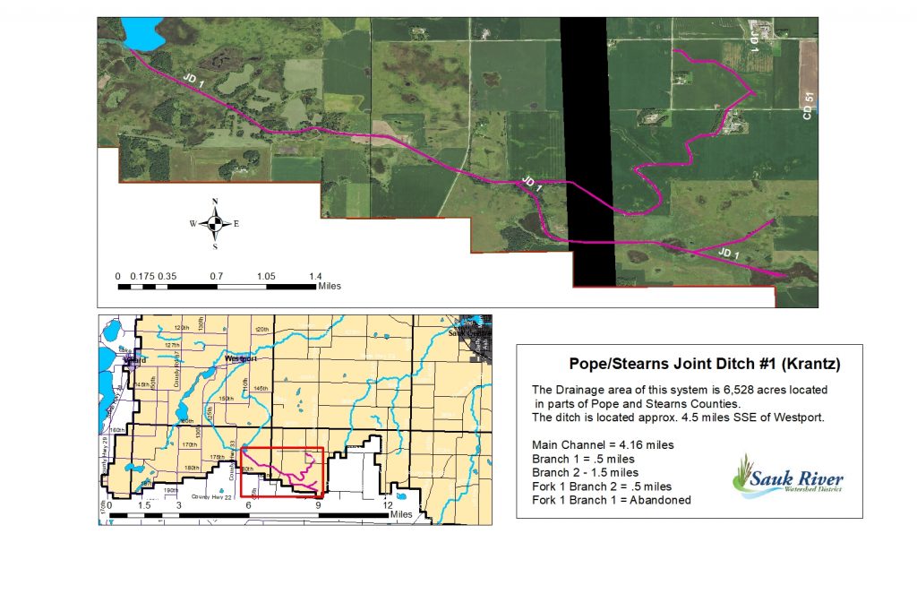
Pope/Stearns Judicial Ditch #1 Location Main Start – Section 8, T-125-N, R-35-W, Raymond Township End – Section 11, T-125-N, R-36-W, Grove Lake Township Branch # 1 Entirely within NE Section 8, T-125-n, R-35-W, Raymond Township Branch #2 Start – Section 16, T-125-N, R-35-W, Raymond Township End – Section 7/18. T-125-N, R-35-W, Raymond Township Branch #2,…
Read MoreStearns County Ditch #51

Stearns County Ditch #51 Location Start – Section 5, T-125-N, R-35-W, Raymond Township End – N 1/4 corner Section 34, T-126-N, R-35-W, Ashley Township Description The headwaters begin approximately 9 miles southwest of the City of Sauk Centre. The ditch has 2.7 miles of tile and 4.5 of open ditch. The main ditch generally flows…
Read MoreStearns County Ditch #26

Stearns County Ditch #26 Location Main Start – Section 25, T-126-N, R-32-W, Millwood Township End – Section 1, T-124-N, R-33-W, Spring Hill Township Branch #1 Start – Section 34, T-126-N, R-32-W, Millwood Township End – Section 2, T-125-N, R-32-W, Oak Township Branch #2 Start – NW Section 2, T-124-N, R-32-W, St. Martin Township End – Section…
Read MoreStearns County Ditch #24
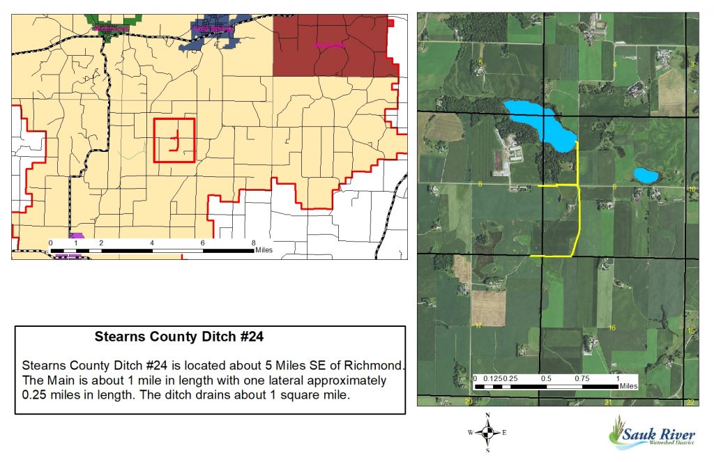
Stearns County Ditch #24 Location Main Length – about 1 mile in length with one lateral about 0.25 miles long. Start – Section 8/17, T-122-N, R-30-W, Luxemburg Township End – NW Section 9, T-122-N, R-30-W, Luxemburg Township Description The drainage area of Stearns County Ditch # 24 is about 413.41 acres, located SE of Richmond and SSW…
Read MoreStearns County Ditch #19

Stearns County Ditch #19 Location Start – Section 7, T-122-N, R-30-W, Luxemburg Township End – Section 1, T-122-N, R-31-W, Eden Lake Township Description County Ditch # 19 is approximately 1.83 miles about four miles northwest of Eden Valley, MN. The ditch consists of two branches off the main stem flowing south then westerly eventually…
Read MoreStearns County Ditch #17

Stearns County Ditch #17 Location Main Length – 3.5 miles Start – Section 36, T-124-N, R-29-W, St. Joseph Township End – Section 13, T-124-N, R-29-W, St. Joseph Township Branch 1 Length – ~ 2 miles Start – Section 35, T-124-N, R-29-W, St. Joseph Township End – Section 25, T-124-N, R-29-W, St. Joseph Township Fork on Branch 1 Length…
Read More